Wandering around the Pieniny
25.05.2015
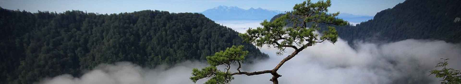
Trip to the top of Zar On one of the first spring expeditions I went with a guide, not far from home, along an extremely picturesque trail in the area of the Pieniny Spiskie, which is not frequented by tourists. We chose the section of the red trail leading from Dursztyn to Niedzica through Żar, Barwinkowa Góra (703 m a.s.l.), Złatne (777 m a.s.l.) and Cisówka (635-720 m a.s.l.). First, we gently traverse Jurgowskie Hale, then a fairly steep climb to the Żar mountain (the mountain, mistakenly entered by Austrian cartographers as Branisko, and by the locals called Hombarkami). Approaching we can first admire the Belian Tatras, High and Western Tatras, later also Magura Spiska with Wiaterny Wierch. When we reach the top, we have to make a longer stop we want to saturate the eyes with an unusual panorama. Of course you can see Huba from our farm Karolina. We had good visibility and could see Babia Góra (the highest peak of the Żywiec Beskids), Gorce with Turbacz and Lubań, at the foot we had the Czorsztyn Lagoon with villages around the lake such as Dębno Podhalańskie, Szlembarg, Huba, Maniowy, Mizerna, Kluszkowce and the nearest visible to us Frydman. I have been a guide for many years, and before that I wandered a lot in various mountain ranges, but I never indifferent to beauty, I am constantly delighted with such views. And a man in the mountains also takes a distance to many things. Further on, our red trail runs through wooded areas, only here and there a bit wider landscapes are shown, it is time to cool down a bit. On the Przełęcz pass you will meet a bicycle trail and a yellow walking trail, you can reach Falsztyn by bicycle route and yellow to Łapsze Niżne. Wonderful views are revealed in the vicinity of Cisówka. The Priens of the Gorce, the Tatra Mountains and the Czorsztyn Lagoon were joined by the Proper Pieniny with the Three Crowns at the head, from our perspective the castles look beautiful: the Royal "Wronin" in Czorsztyn and the "Dunajec" castle in Niedzica. Before we get to Nadzamcza, we visit the old, private cemetery of the Hungarian Salamon family - The cemetery is located at the foot of the limestone rock called Groby (604 m a.s.l.). It was founded by Mrs. Ilona in 1936, who moved here the graves of her loved ones. She and her son died in Hungary. Our trip is coming to an end, it's time to go home for the night. The best part is that I will be able to see all the peaks I have just gone through from the window of the room. American Liberator in Gorce Sunday trip. Quite mild winter, you can go skiing or hiking. Not to get out of practice. This time I went to Gorce, I visited "Gorczańska Hut" but the main goal was to reach the vicinity of Pańska Prehybka where on December 18, 1944 a heavy American B-24 J Liberator bomber crashed. her own name "California Rocket" belonged to 757 Squadron, 459 Bomber Group, 304 Wings, 15th United States Air Army, operating from Italy. On the trails, the biggest obstacle were fallen trees, in places you had to work hard, but it was worth it. For lovers and not only If you are in the area of Spisz I recommend visiting the village: Krempachy. We will find here a beautiful cemetery church dedicated to the patron of lovers - Saint. Valentine. built in 1761 with a valuable Gothic triptych from 1516. The barrel vault with lunettes is divided into boxes filled with plaster ornaments. The main altar is decorated with a picture of saints: Stanisław, Walenty and Mikołaj - the so-called holy conversation, cult of St. Valentine - healer of all diseases, especially epilepsy and advocate of hopeless cases (as you can see he has the best predisposition to be the patron of lovers) is still ongoing and even developing. To the spread of the cult of St. Valentine's Day has recently contributed to the increasingly fashionable holiday brought from across the ocean, the holiday of lovers so-called "Valentine's Day". When we get here at the indulgence, we find a festively dressed church, a long queue for "indulgence candles" around the altar, singing a schola, playing an orchestra, and a long row of stalls with sweets and other indulgence attractions. Returning to the village of Krempachy, it should be added that the name of the village probably comes from the German Krummbach which means a winding stream, it refers to Dursztynski Potok (formerly Kręcin). Currently, the village has buildings typical for Spiš villages. the spindle market was created from the split of the main axis into two roads converging at its ends. At the market stands the parish church of St. Marcin, and on both sides houses facing the road and rows of barns surrounding the building at a distance from the houses (mainly for fire reasons). The priest is priest Dariusz Ostrowski, whose passion is photography and mountains (he is a Beskid guide). He is the author of the beautiful album "Znak Nadziei" published by the publishing house of the Theological Institute of Missionary Priests. The album shows the beauty and majesty of the cross on Polish soil. The green tourist trail runs from Krempachy from Nowa Biała to Dursztyn, in the area there is the Białki Przełom nature reserve near Krempachy, where you can see, among others relict rock vegetation. Obłazowa Cave - The Białki Gorge There are several reserves in the Pieniny, such as the White Water Reserve, Homole, Wysokie Skałki, Zielone Skałki. There is also a less-known Białki Gorge reserve, it covers a short section of the Białka River, between Kramnica (688 m a.s.l.) and Obłazowa (670 m a.s.l.). In addition to these two larger rocks, there are several smaller ones (among others, Round Rock). The reserve belongs to two geographical regions: Kramnica is located in the Spiš Pieniny, and Obłazowa in the Orawsko - Nowotarska Basin. The border is the Białka River. Once the Polish-Hungarian border ran here, now it is the border between Spisz and Podhal. However, both of these rocks are of the same origin and once constituted one massif. They were cut by the river, which created a 100 m wide gorge in them. Its riverbed is lined with granite pebbles brought from the Tatra Mountains. For the first time a nature reserve was created here in 1931 on an area of 7.5 ha, in 1959 the area was increased to 8.51 ha. It has great natural, landscape and scientific values. Relic rock vegetation and archaeological monuments occur here. In the Obłazowa massif you will find 2 caves and a 9-meter-long Obłazowa Cave. During archaeological research conducted in 1985-92, traces of man from different eras were discovered. These are the oldest traces of man in the Pieniny - come from before 40 thousand. years. During research carried out in the years 1989–1995, a well-preserved one, dating back to 30,000, was found in the cave. years boomerang from a mammoth blow, (the oldest boomerang in the world). The remains of animals from this period were also found, among others: the woolly rhinoceros, the cave lion, the cave hyena. Fossils are visible on the walls of Obłazowa, mainly Jurassic ammonites. The surroundings of the reserve are attractive for tourists and holidaymakers. Nearby there are other limestone rocks (Dursztyńskie Rocks, Cisowa Rock). Białka is one of the cleanest and coldest rivers in Poland, it cools down in hot weather, and its stones are used as a beach. From the summit of Kramnica and Obłazowa you can see the whole area from the Czorsztyn Lake to the Tatra Mountains on one side and Gorce on the other. These rocks are attractive for rock climbers. There are about 30 climbing routes of varying difficulty: from 30 m in height in the wall of Kramnica (rings, fasteners, posts from two points connected by chains with a steel screw carabiner) to shorter and less insured in Obłazowa. Some scenes for the films "Janosik", "The Third Border" and "Karol" were shot in the reserve. The man who became pope. " The unusual village of Huba Huba, the smallest village of the Czorsztyn commune. Picturesquely situated in the Gorc range. has 40 houses. The village was founded at the beginning of the 17th century and was part of the Czorsztyn Starosty. Today, no one can say why the village was located so high, on the slopes of Kotelnica away from roads, streams and rivers. The local population has always been struggling with water scarcity. This problem was solved only in the 1950s. The inhabitants of Huby built a water pipe themselves. The first inhabitants of the village were members of four families: Plewów, Kubiczów, Bednarczyk and Płonkowski. I mention here the names of these families not without reason. Well, until the nineteenth century, the peasants did not have surnames in today's sense, in those days the peasants used the nicknames and they were not always inherited. Sometimes, the nicknames indicated the profession being performed. Thanks to this, we know what the first inhabitants of Huby did, and so: Plews - they cultivated fields and sown them mostly with oats. Kubicze - they were involved in logging and logging. The Bednarczyk family - produced, among others, barrels, bulbs, buckets, cans, etc. The most interesting occupation was the Płonkowski family. This family produced kindling from the hub growing on trees without which no farm could do without. Tinder was obtained by processing hubs harvested in the surrounding forests. Hubs of the right size were collected from the beech, they could not be too big and woody and they could not be too small and fleshy, then the hubs were cooked for up to 70 hours. After cooking, they were drained and special choppers, mashed, dried and broken again until cotton wool material was obtained. Such a prepared hub was used to kindle bonfires or you could just light a pipe. Of course, you also had to have a tinder. I devoted quite a lot of space to the description of the tinder product, but it is to Płonkowski and their profession that Huba got its name. On the other hand, thanks to the whim of the Czorsztyn starosts, Huba is located high in the mountains, currently it has a unique and extensive panorama. You can see: Lubania range, Pieniny range with Three Crowns and High. You can see the entire range of the Tatra Mountains (Belian, High and West Tatras). From the west, the panorama closes Babia Góra, and in the north - Turbacz west. At the foot of Huba, the surface of the Czorsztyn Lagoon shimmers beautifully, you can also see the Dunajec and Białka rivers supplying the lagoon with the gorge. Huba, in addition to unique views, can also give you peace and quiet, there is no through route here, only a comfortable wide asphalt road leading to the village. We can see an old chapel in the village, and outcrops of nature here are rock outcrops. I hope that I managed to convince you that it is worth to deviate from the beaten paths and visit the village of Huba to admire the picturesque view in peace and quiet. Chapel in the village of Huba In our village Huba we do not have a church, there is only a tiny, charming chapel. In May, residents and tourists come here to sing Marian songs together. It was built of field stones as thanksgiving in a place where an unusual view of several mountain ranges extends. From here you can see Gorce with Turbacz, Pieniny with Three Crowns, Tatra Mountains, Żywiec Beskids and Babia Góra. You can see the castles in Niedzica and Czorsztyn, the Białka gorge and the Dunajec valley with the Czorsztyn Lagoon. Two versions of the legend spread among the inhabitants about the reasons for the construction. According to some, the chapel was built as a thank you for miraculous survival. In a field work chat, one of the hosts was lifted into the air by a whirlwind. Scared, he began to pray to the Mother of God and asked for help. The wind stopped and the host landed safely on the ground. In the place of his survival, he built a chapel in thanks and as a souvenir. According to others, the chapel was erected by the host who wanted to thank in this way for his son: For several years he tried for a descendant, but only when he began to ask Mary for help, his dream came true, happy and proud, he put the chapel on the hill - by the road to everyone knew who owed their happiness.